CORE BUSINESS
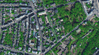
WEO SAS, founded and registered in Luxembourg in 2020, was formed with an aim to improve global environmental sustainability, to enable a more sustainable society. WEO employs deep learning and satellite data to enhance urban sustainability and resilience, offering environmental analytics to cities and facilitating the deployment of green infrastructure. By transforming satellite imagery insights from their native, lower-resolution state to high-resolution, we leverage openly accessible satellite data, enabling our clients to receive vital, scalable information regularly and affordably. For instance, WEO monitors green roofs, land surface temperature, surface sealing, and vegetation management to address urban heat, flood, and wildfire risks while promoting biodiversity.
PRODUCTS & SERVICES
Our main products are maps and services related to water resource management and tree management for sustainable cities and agriculture using open access data from space (sentinel missions mainly). A list of our products and services include:
- Tree management (Tree extent, tree height, tree location, tree growth and tree health)
- Mapping of potential for green roofs in urban areas
- Mapping of potential to convert permeable surfaces (i.e. parking spaces) to impermeable areas for water infiltration
- Land surface temperature mapping (urban heat of different surfaces)
- Flood risk mapping
- Vegetation Risk to Assets
- Wildfire risk mapping
TECHNICAL MEANS
Both cofounders, Charlotte Wirion, CTO and Imeshi Weerasinghe, CEO have PhD topics focused around water resource management in the urban or agricultural fields using remote sensing (space) data. Charlotte Wirion was also Guest Professor in Urban Hydrology and Remote Sensing at the Vrije Universiteit Brussels.
MAIN CUSTOMERS
- Ville de Luxembourg
- Luxembourg Water Agency (AGE)
- European Space Agency (ESA)
- ProSud
- Brussels Environment
- Luxembourg Ministry of Environment
- Shroeder&Associates
- SIAS - Australian Red Cross
MAJOR SPACE PROJECTS
- Smart Urban Tree Feasibility Project with ESA, LSA and Ville de Luxembourg LuxImpulse
- Sustainable Water Resource Management (SWARM) with ESA, LSA and Luxembourg Water Agency.
- TreeMonitor – ESA, VDD, VDL and CFL
- UrbanGreen – Madrid and Widlfire risk project with ESA; Prosolia and Jogosa


